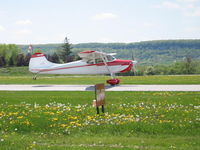
hi fellow 170 flyers.
i have read this post with great interest,
and have tried to convince myself
that i need to own a GPS.
as of yet, i remain unconvinced!
i fly to Lincoln, Ne, Fargo, SD, and
Clow airport which is in the west chicago suburbs.
AND of course to oshkosh everyother year,
as my partner likes to go on RAGBRAI,
with happens to fall on the exact same time.
i enjoy flying VFR and by the very basics.
i enjoy calculating ground speed, ETA etc.
the old fashioned way.
to me this is flying.
i obtained my instrument rating in 84' but rarely use it.
and like spock says on 'star trek'
have a A7 computer rating!!
but, i still like to do it the old way.
to date, i've never been lost,
my ETA's are within 5-10 minutes,
and in short, i've never had a problem
doing it this way.
am i missing something?
why should i spend 2750 for
s.t. that will continually need $ upgrades
or monthly fees,
when a simple sectional would suffice?
convince me!
dave
Which Aviation GPS is the best for the money???
Moderators: GAHorn, Karl Towle, Bruce Fenstermacher
-
Dave Clark
- Posts: 894
- Joined: Mon Apr 22, 2002 6:25 pm
Johnjrenwick wrote:I It comes with a 32 meg MMC data card, which is too small to make much use of the surface map data they provide. So I bought a 512 meg SD card, because my camera can use it, and Lowrance says the unit supports both MMC and SD card types.
When you buy a database update from Jepp for this thing, it's registered to the data card, not to the GPS unit. So if you have multiple data cards, you've got to buy the database separately for each one. The database that comes with the unit is registered to the 32 meg card they supply, and it can't be used with a bigger card.
I called Lowrance's software tech support (a free call), and they talked
John
That has not been the case with my 2000. In fact I moved the Jepp file to a 1G SD card I bought so I could get about 80% of the roads data for a long RV trip. Worked fine.
Dave
N92CP ("Clark's Plane")
1953 C-180
N92CP ("Clark's Plane")
1953 C-180

Ha! Yeah I know what you mean, Dave! But I used to say the same thing about Windows when I still ran my 286 DOS computer. Then one day, I finally broke down and bought aKLN88 Loran for $150 when it's owner couldn't live without GPS. I laughed and laughed at him, and really felt good about my decision to actually install some sort of NAV radio in my 170 (which previously had nothing at all to nav with other than my wits and my setionals.) Then when the guvmint went crazy with restricted airspace, TSA's/TRA's, etc etc, I finally decided it'd be nice to have a graphic display of them.iowa wrote:hi fellow 170 flyers.
i have read this post with great interest,
and have tried to convince myself
that i need to own a GPS.
as of yet, i remain unconvinced!
i fly to Lincoln, Ne, Fargo, SD, and
Clow airport which is in the west chicago suburbs.
AND of course to oshkosh everyother year,
as my partner likes to go on RAGBRAI,
with happens to fall on the exact same time.
i enjoy flying VFR and by the very basics.
i enjoy calculating ground speed, ETA etc.
the old fashioned way.
to me this is flying.
i obtained my instrument rating in 84' but rarely use it.
and like spock says on 'star trek'
have a A7 computer rating!!
but, i still like to do it the old way.
to date, i've never been lost,
my ETA's are within 5-10 minutes,
and in short, i've never had a problem
doing it this way.
am i missing something?
why should i spend 2750 for
s.t. that will continually need $ upgrades
or monthly fees,
when a simple sectional would suffice?
convince me!
dave
I figured $800 spent on a Garmin 196 was better'n three times that spent on a lawyer and a suspension!
'53 B-model N146YS SN:25713
50th Anniversary of Flight Model. Winner-Best Original 170B, 100th Anniversary of Flight Convention.
An originality nut (mostly) for the right reasons.
50th Anniversary of Flight Model. Winner-Best Original 170B, 100th Anniversary of Flight Convention.
An originality nut (mostly) for the right reasons.
The best deal rght now is a used garmin 196-stick it on the glareshield if you can. IMHO
Ive been using a glareshield mounted garmin 3 for 11 years-works out to $50 a year.
Iloved my flybuddy loran, but it crapped out 3 years ago, looking [not too hard] for a flybuddy gps to replace it.
I remember 25 years ago when noise attenuating headsets were gaining acceptance. A buddy said he didnt want one because he wanted to hear the engine. After wearing my David Clarks for an hour he bought his own. Moving-map GPS is the same way.
Tracy Ake
1955 cessna 170b
sn26936
N2993D
1955 cessna 170b
sn26936
N2993D
A friend of mine was tracked down by men in suits with badges for allegedly skirting the frequently occuring central Texas restricted airspace. After a few minutes of conversation which seemed to be going downhill fast my friend told the suit that he could recall the track of his flight on his Garmin 196 and prove he didn't violate the airspace. This revelation quickly changed the tone of the meeting and the nice man in the suit went on his way. I think George is right on with his comment. If you pay attention to the GPS and stay out of restricted airspace it's cheap insurance!gahorn wrote:I figured $800 spent on a Garmin 196 was better'n three times that spent on a lawyer and a suspension!
I say more power to ya....... I'm sure you have pilotage skills far and above most, and that is a good thing. One thing to remember is that approach is not responsible for keeping you out of any airspace if you are VFR. Even if they give you a heading that puts you in airspace you shouldn't be in it is still your responsibility. Someone I know (very,very welliowa wrote:i'm still not convinced!
i know i'm out in the middle of nowhere here in iowa,
but when i do go over a restricted zone like omaha,
i always call approach control,
and they tell me where to fly.
dave
Last edited by N2865C on Wed Nov 01, 2006 9:40 pm, edited 1 time in total.
John
N2865C
"The only stupid question is one that wasn't asked"
N2865C
"The only stupid question is one that wasn't asked"
-
Curtis Brown

- Posts: 273
- Joined: Tue Apr 23, 2002 3:47 pm
One of the best ways to get disoriented is to be looking down in your lap at a chart at low altitude in poor visibility. The best way to get your wits back is to look at your GPS map.
Safety is priceless! The nearest airport feature on a GPS could save your life.
Also, I believe the GPS moving map and data base adds enjoyment to my flying. To have all that info with a touch of a button enables the pilot to be looking out the windshield more.
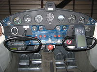
I use a panel mounted KLN 90B and a yoke mounted Garmin on the co-pilot side.
Safety is priceless! The nearest airport feature on a GPS could save your life.
Also, I believe the GPS moving map and data base adds enjoyment to my flying. To have all that info with a touch of a button enables the pilot to be looking out the windshield more.
I use a panel mounted KLN 90B and a yoke mounted Garmin on the co-pilot side.
Curtis
1950 A model 1256D
1950 A model 1256D
you all have good points!
but i still think they are just expensive toys.
(i confess i have a lot of these anyway,
56 vette, 5 wwii jeeps, a bobcat etc, etc.)
i guess i'm from the old school,
plot out your course the night before,
being aware of way points, and all airports etc.
the places i fly, i rarely consult the chart,
as i've flown these courses so often.
i guess the only problem would be battery failure,
but i assume each of you put new
or recharged batteries in
with each flight.
my charts have not failed me yet.
dave
1951 170A 1468D SN 20051
1942 L-4B 2764C USAAC 43-572 (9433)
AME #17747

GPS means having additional information; that's all it is, really. You can certainly navigate without it, although not as precisely, especially if you're relying on VOR. It means having a constant running fix on your position. It means having the solutions to all your navigation calculations instantly at hand.
The additional information a good GPS receiver can give you over your own pilotage can be more than just helpful. Many people consider it such an enhancement to safety that they wouldn't fly without it, and I certainly respect their position.
It's a mistake to navigate solely by reference to GPS, because it can fail (I've had that happen more than once). Drawing your course on a chart and keeping it in front of you, along with planned groundspeed, flight time, and fuel requirements, is just good flight planning practice, and GPS shouldn't substitute for that. But by all means, program that flight plan into your GPS unit, too!
By the way, I also use CoPilot on my PDA to do all my flight planning. It's very inexpensive, the airport and navaid database downloads are free, and it's one of the best-designed pieces of software of any kind that I've ever used. It lives here: http://lauriedavis9.tripod.com/copilot/.
Best Regards,
John
John Renwick
Minneapolis, MN
Former owner, '55 C-170B, N4401B
'42 J-3 Cub, N62088
'50 Swift GC-1B, N2431B, Oshkosh 2009 Outstanding Swift Award, 2016 Best Continuously Maintained Swift
Minneapolis, MN
Former owner, '55 C-170B, N4401B
'42 J-3 Cub, N62088
'50 Swift GC-1B, N2431B, Oshkosh 2009 Outstanding Swift Award, 2016 Best Continuously Maintained Swift

souns
IOWAY, ITSA SHOR SOUNS LAK U DOANT WANNA BE CONVINCE  SO WHY SHUD WE TRI? SUMPIN ABOUT "WE NEVER DUN IT THATAWAY BEFOR" IS A COMFERT TO SUM.
NOAW IMMA GONNA TOLE U SUMPIN U PROLLY DOANT NO. SUMMA GUYS HYEAR S A GONNA LIE BOUT IT AN STRETCH IT INTU SUMMPIN IT AINT BUT COUPLE YEAR AGO, WHEN I NOK MY LIL 315 OUT THU WINNO OF DEENIE'S LIL 150 ON THU WAY TO PETTY GENE, I DINT BOUT PEE MY PANS . I DINT NO WHERE I WUZ EZAKLY BUT I HAD DEENIE
  SO I JES LOOK AT HER AN SAY "YOUR TURN TO FLY HONEY" SHE ALREADY NEW WHERE SHE WUZ AN TOOK US RITE THERE. BAD THANG BOUT LOSIN MY LIL 315 WUZ ALL MY FAVORITE FISHIN SPOTS I HAD MARK, WENT OUT THE WINNO TOO. SUM DANG DEER HUNTER PROLY FOUND THAT LIL JEWEL THAR IN THEM ARKY HILLS AND WENT LOOKIN FER ANOTHER LOST GUY!
USIN ONE OF THEM GEE PEE ESS'S - IT DO MAKE A FELLER A LIL LAZY BUT AS FER WRASSLIN ROUN AN UNFOLDIN A 3 FOOT LONG SEC MAP AN TRYIN TO REFOL UP ONE IS LOTS MORE LESS FUN THAN POKIN LIL BUTTONS AN SE'EN WHAT TIME THE SUNS GONNA COME UP TOMMORY AN WHENS THE BES FISHIN TIME OR WHAT RIVER U JES CROSS THATSA GOT SOME NICE LOOKIN FISHIN HOLES. STAB THE LIL "MOB" BUTTON, NAME THE LITTLE SECRET HOLE THEN GO BACK LATER IN URE JEEP AN TRY URE LUCK!
NUTHER TIME WHEN I BRING THE C175 FROM AZ TO LA AN DINT NO TOO MUCH BOUT THE FUEL GAUGES I HAD'DA USE THAT LIL BUTTON FER "NEAREST". I SWICH FRUM "BOTH" TO "RIGHT" AN SHORTLY IT SUCKED FUMES LIL JEWEL SHOWS ME "WINKLER COUNTY AIRPORT" 14 MILES SOUTH EASTY. FRUM 12000' I MADE A BEELINE AN DINT EVEN DO NO DOWN WIND JES STRATE IN! PUT IN 40 GALLONS
MY FWIW
HEEEE HAWWW OLE GAR GOTS HIM A NEW ONE THOUGH, BUT FOUN OUT IT AINT WORT DOODLE IN ALASKY! ZOOM OUT FUR ENOUGH AN YOU KIN SEE THE HOLE STATE BUT NOT MUCH MOR. I SPECT A 196 OR BETTER WUD SHOW MORE DETALES BUT I DINT LOOK A GIF HORSE INNA MOUTH..
NOAW IMMA GONNA TOLE U SUMPIN U PROLLY DOANT NO. SUMMA GUYS HYEAR S A GONNA LIE BOUT IT AN STRETCH IT INTU SUMMPIN IT AINT BUT COUPLE YEAR AGO, WHEN I NOK MY LIL 315 OUT THU WINNO OF DEENIE'S LIL 150 ON THU WAY TO PETTY GENE, I DINT BOUT PEE MY PANS
USIN ONE OF THEM GEE PEE ESS'S - IT DO MAKE A FELLER A LIL LAZY BUT AS FER WRASSLIN ROUN AN UNFOLDIN A 3 FOOT LONG SEC MAP AN TRYIN TO REFOL UP ONE IS LOTS MORE LESS FUN THAN POKIN LIL BUTTONS AN SE'EN WHAT TIME THE SUNS GONNA COME UP TOMMORY AN WHENS THE BES FISHIN TIME OR WHAT RIVER U JES CROSS THATSA GOT SOME NICE LOOKIN FISHIN HOLES. STAB THE LIL "MOB" BUTTON, NAME THE LITTLE SECRET HOLE THEN GO BACK LATER IN URE JEEP AN TRY URE LUCK!
NUTHER TIME WHEN I BRING THE C175 FROM AZ TO LA AN DINT NO TOO MUCH BOUT THE FUEL GAUGES I HAD'DA USE THAT LIL BUTTON FER "NEAREST". I SWICH FRUM "BOTH" TO "RIGHT" AN SHORTLY IT SUCKED FUMES
MY FWIW
HEEEE HAWWW OLE GAR GOTS HIM A NEW ONE THOUGH, BUT FOUN OUT IT AINT WORT DOODLE IN ALASKY! ZOOM OUT FUR ENOUGH AN YOU KIN SEE THE HOLE STATE BUT NOT MUCH MOR. I SPECT A 196 OR BETTER WUD SHOW MORE DETALES BUT I DINT LOOK A GIF HORSE INNA MOUTH..
OLE GAR SEZ - 4 Boats, 4 Planes, 4 houses. I've got to quit collecting!
My Garmin 195 has a great moving map display that is easy to read. The database can be updated for $35 (much cheaper that replacing sectionals every time they are updated). Restricted, and controlled airspace awareness is priceless. I bought it used on ebay for less than $300, and can't believe how nice it works on nicads on my control wheel (no extra antenna). I carry a spare alcaline battery pack as backup.
Sure, if I lived in a mountainous area again, I would pay the extra for terrain information. Snow showers can sneak up on you so fast, and leave you in deep trouble. Great map reading skills is important, but solid information can save your life.
You can always keep the GPS in the glove box, to be pulled out when the going gets tough. The truth is, you may not be farmiliar enough to use it safely if you haven't used it recently.
My panel mounted Flybuddy 800 loran was the best $150 I've spent in the last 5 years! It also can be updated with the latest Jepp info, but it costs about $100.
Cheers Eric
I was just readin thru on my way to explainin why I like panel mount vs portable and come across Ole Gar trying to stick to his story.
Imagine yourself on a cross country rescue mission, somewhere over Siberia, the entire free world depending on your success, and all of a sudden your GPS up and fly's out the window!
Somethin was goin on in that fuse lodge, that caused that GPS to jump!
Imagine yourself on a cross country rescue mission, somewhere over Siberia, the entire free world depending on your success, and all of a sudden your GPS up and fly's out the window!
Somethin was goin on in that fuse lodge, that caused that GPS to jump!